1st map for2
2nd map for 3
4th map for 4
2 - Use the map below to...

1st map for2
2nd map for 3
4th map for 4
2 - Use the map below to answer the following question:
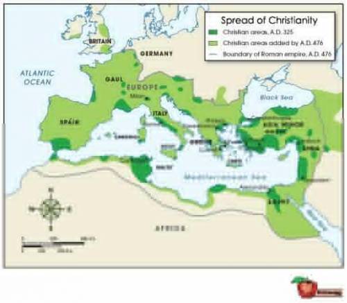
Map of Europe and North Africa labeled, Spread of Christianity. Dark green indicates Christian areas, 325 AD. The dark green areas are small, isolated patches surrounding the Mediterranean Sea. Light green indicates Christian areas added by 476 AD. Most of Spain, Gaul, Italy, Greece, and Asia Minor are light green. The light green extends to the European inland, and as far north as parts of Great Britain. It also extends to part of Egypt, Syria, and the North African Mediterranean coast. A grey line indicates the boundaries of the Roman Empire, 476 AD. This line extends around the Mediterranean, from North Africa in the south, beyond Jerusalem to the east, and into northern Gaul.
© 2012 The Exploration Company
Which statement can be said to be true, after examining this map?
By 476 AD, Christianity had spread to all of the boundaries of the Roman Empire.
By 476 AD, Christianity had extended far beyond all of the boundaries of the Roman Empire.
By 476 AD, Christianity had spread to most of the Roman Empire, and, in some cases, past those boundaries.
By 476 AD, Christianity had begun to decline within the boundaries of the Roman Empire.
3-Use the map below to answer the following question:
Map of Europe and North Africa labeled, Spread of Christianity. Dark green indicates Christian areas, 325 AD. The dark green areas are small, isolated patches surrounding the Mediterranean Sea. Light green indicates Christian areas added by 476 AD. Most of Spain, Gaul, Italy, Greece, and Asia Minor are light green. The light green extends to the European inland, and as far north as parts of Great Britain. It also extends to part of Egypt, Syria, and the North African Mediterranean coast. A grey line indicates the boundaries of the Roman Empire, 476 AD. This line extends around the Mediterranean, from North Africa in the south, beyond Jerusalem to the east, and into northern Gaul.
© 2012 The Exploration Company
Where did most Christians live in 325 AD?
along the coasts of the Roman Empire
away from the coast of the Roman Empire
along the coast of Northern Africa
near the city of Italy, near Rome
4-Use the map below to answer the following question:
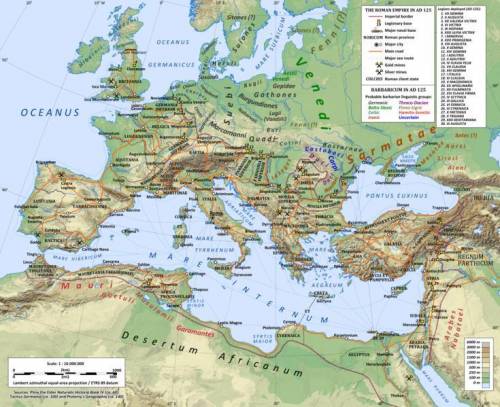
A physical map of Europe, North Africa, and Western Asia showing major locations within the Roman Empire and its borders around 125 CE. The lowest elevation areas are shaded green and are along the northeastern coasts of North Africa, northern Europe, and the western coast of Spain. The highest elevation areas are shaded light brown and are in southwest Asia, across southern and southeastern Europe, most of Spain, and the northwestern coast of North Africa.
© 2012 Andrein
Creative Commons, Attribution-Share Alike 3.0 Unported
Which of the following best explains why the area between Spain and Gaul was not part of the Roman Empire until 107 CE, even though the surrounding areas were both part of the empire for many years?
This area was populated by highly organized warriors.
Rivers in this region made it difficult to access.
This area was seen as undesirable by the Romans.
Mountains made this region difficult to access.


Answers: 1
Another question on History
History, 21.06.2019 23:30
What side of the american civil war would you choose to fight for and why
Answers: 1
History, 22.06.2019 00:00
What office did janet reno hold in the state of florida before becoming the first female united states attorney general
Answers: 1
History, 22.06.2019 05:20
According to the article, what did plato and aristotle have in common?
Answers: 2
History, 22.06.2019 05:30
Europe and asia are divided by a. the alps c. the pyrennes b. the northern european plain d. the ural mountains select the best answer from the choices provided a b c d
Answers: 1
You know the right answer?
Questions

Mathematics, 26.08.2019 05:00
Mathematics, 26.08.2019 05:00

Physics, 26.08.2019 05:00
Mathematics, 26.08.2019 05:00

Advanced Placement (AP), 26.08.2019 05:00

Social Studies, 26.08.2019 05:00
Mathematics, 26.08.2019 05:00
Mathematics, 26.08.2019 05:00


History, 26.08.2019 05:00
Physics, 26.08.2019 05:00
Mathematics, 26.08.2019 05:00
Social Studies, 26.08.2019 05:00


