
Geography, 04.01.2020 10:31 chocolate1294
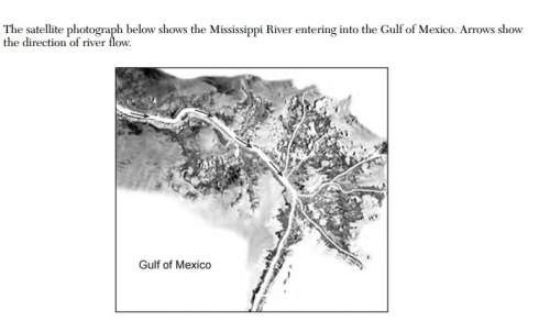
The satellite photograph below shows the mississippi river entering into the gulf of mexico. arrows show the direction of river flow.
this depositional feature in the gulf of mexico is best identified as
(1) a delta
(2) a sandbar
(3) a barrier island
(4) an outwash plain

Answers: 1
Another question on Geography
Geography, 23.06.2019 15:30
Giving an address, such as "1000 elysian park avenue, los angeles, .ca, its an example of describing the
Answers: 2
Geography, 23.06.2019 20:30
Use complete sentences to describe scientists’ predictions for another earthquake in the same location. if applicable, provide an anticipated date of reoccurrence.
Answers: 2
Geography, 24.06.2019 01:00
Which phrases describe oxygen's roles in earth’s atmosphere? check all that apply. allows fuels to burn forms clouds that produce rain is the gas that animals breathe is used by plants to produce food forms ozone that absorbs the sun's harmful rays
Answers: 1
You know the right answer?
The satellite photograph below shows the mississippi river entering into the gulf of mexico. arrows...
Questions

English, 25.11.2020 02:00
English, 25.11.2020 02:00

Mathematics, 25.11.2020 02:00


Advanced Placement (AP), 25.11.2020 02:00

Business, 25.11.2020 02:00
Mathematics, 25.11.2020 02:00
Mathematics, 25.11.2020 02:00

Biology, 25.11.2020 02:00

Chemistry, 25.11.2020 02:00
Chemistry, 25.11.2020 02:00
Mathematics, 25.11.2020 02:00

Computers and Technology, 25.11.2020 02:00


