
This map shows the intensity of drought conditions across the United States. Using the information on the map, which technologies could help California reduce the effects of the natural disaster it is experiencing?
A: build storm cellars
B: install hurricane shutters
C: build dams
D: use domestic water conservation devices
E: use hurricane ties
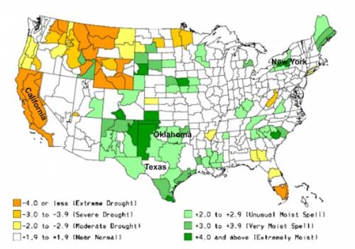

Answers: 3
Another question on Geography
Geography, 21.06.2019 15:30
How much of the united states’ electric generation comes from coal? a. about 25% b. about 50% c. about 75% d. about 90%
Answers: 1
Geography, 22.06.2019 17:30
Asap! ! ! western china, northern china and southeastern mongolia are all located in what climate zone? tropical wetdesert humid subtropical humid continental
Answers: 2
Geography, 23.06.2019 16:00
List 3 factors commonly used to select the location of a city
Answers: 1
Geography, 23.06.2019 21:40
Directions you probably already know that people have different ways to organize their ideas. some people make lists or outlines, some draw pictures, while others may combine these two methods. experiment with different note-taking techniques to find the one which works best for you. one common note-taking technique is webbing. webbing uses the sizes of circles to indicate the importance of items. lines are used to indicate the relationships between items. the example below is based on the information presented in a previous lesson. notice that the circle for "geography is" appears at the center of the web. it has larger than the circles that surround it. the "geography " circle is surrounded by smaller circles of earth's atmosphere, earth's climate, earth's surface. notice the lines that connect these items to the concept of geography. notice that the circles surrounding atmosphere are smaller. also observe that the lines that connect the items and indicate the relationships between the items. webbing will you capture the most important points in your lessons. beginning with lesson two, geographic tools: globes and maps, use webbing to take notes on the important information in this unit. hint: it will be easier to complete this project if you take your notes after completing each lesson.
Answers: 1
You know the right answer?
This map shows the intensity of drought conditions across the United States. Using the information o...
Questions

Mathematics, 25.08.2020 07:01

Arts, 25.08.2020 07:01


English, 25.08.2020 07:01

History, 25.08.2020 07:01
Mathematics, 25.08.2020 07:01
History, 25.08.2020 07:01
Mathematics, 25.08.2020 07:01
Mathematics, 25.08.2020 07:01
Mathematics, 25.08.2020 07:01

Spanish, 25.08.2020 07:01
English, 25.08.2020 07:01

Mathematics, 25.08.2020 07:01
Mathematics, 25.08.2020 07:01


