
Geography, 03.08.2020 19:01 sipstick9411
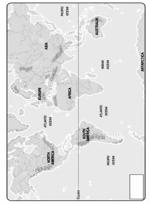
Using a red-colored pencil, trace the patterns of the prevailing winds on the map. Be sure to include the following prevailing winds: Prevailing Westerlies Trade Winds Northern Subtropical Gyre Southern Subtropical Gyre Doldrums Draw arrows on each pattern to show which direction the wind blows. Label the various prevailing winds with their appropriate names. Sketch the major ocean currents onto the map using a blue-colored pencil. Be sure to include the following ocean currents: Japan Current Northern Equatorial Drift Southern Equatorial Drift Gulf Stream West Wind Drift Brazil Current Draw arrows on each pattern to show which direction the surface current flows. Label each ocean current pattern with its correct name. In the box provided, create a legend, being sure to key the different colored lines. Finally, label your map with an appropriate title. Answer the following questions. Questions Compare the direction of the currents in the North Pacific Ocean with those of the South Pacific Ocean. How are they alike and similar? Explain the reason for the similarities and differences. What relationship between wind and ocean currents do you notice after observing your map?

Answers: 3
Another question on Geography
Geography, 23.06.2019 09:30
The earth rotates on its axis and revolves around the sun every
Answers: 1
Geography, 23.06.2019 18:00
Which ecosystem best fits the characteristics listed below? which ecosystem best fits the characteristics listed below? ii. seasonal migrations of millions of wildebeests, zebras, and elephants iii. large numbers of predators, such as lions iv. acacia trees and grasses a. the congo rainforest b. the african mangroves c. the serengeti grasslands d. the sahel
Answers: 1
Geography, 23.06.2019 19:00
Which characteristics of temperature and salinity have the greatest influence on the movement of deep-ocean currentsa. warm and low salinityb. cold and high salinityc. cold and low salinityd. warm and high salinity
Answers: 1
Geography, 23.06.2019 21:30
In recent times, what parts of texas are most likely to gain to representatives based on redistricting in recent years
Answers: 1
You know the right answer?
Using a red-colored pencil, trace the patterns of the prevailing winds on the map. Be sure to includ...
Questions

Mathematics, 06.05.2020 02:41


Mathematics, 06.05.2020 02:41


History, 06.05.2020 02:41


