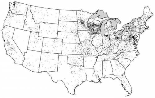
A. Identify ONE type of boundary data shown on the map.
B. Identify the region of the Un...

Geography, 09.04.2020 08:16 katherineweightman
A. Identify ONE type of boundary data shown on the map.
B. Identify the region of the United States where most dairy farms are located.
C. Identify ONE spatial pattern shown on the map.
D. Describe the characteristic land use associated with the spatial pattern shown on the map.
E. Describe TWO geographic features not shown on the map that would help explain the patterns of dairy farming shown on the map.

Answers: 1
Another question on Geography
Geography, 22.06.2019 10:00
Great britain and japan are both island nations with limited resources. as a result, each nation developed according to its distinctive geographic location and limitations. for this assignment, compare and contrast the effects of geography on the industrialization and imperialistic growth of these two nations. use evidence from at least five documents in your essay. support your response with relevant facts, examples, and details.
Answers: 1
Geography, 22.06.2019 17:40
Which factors add to the greenhouse effect and are caused by human activities?
Answers: 1
You know the right answer?
Questions


Chemistry, 14.04.2020 22:45

English, 14.04.2020 22:45


Mathematics, 14.04.2020 22:45


History, 14.04.2020 22:45
Chemistry, 14.04.2020 22:45
Mathematics, 14.04.2020 22:45


