
Geography, 25.09.2019 00:10 dinosaur10
From the map below, what can you infer about the inca cities? map titled map of inca empire road system. a smaller map shows that the inca system of roads runs along the northwest coast of south america in a mountain region. the key shows circles for cities or towns. lines show main roads that a run north to south along the northwest coast. the roads run from ecuador in the north down through peru, between chile and bolivia, and down through argentina. dotted lines show connecting roads.
a) most inca cities were in farming communities.
b) most inca cities were deep in the mountains.
c) most inca cities were located along the main roads.
d) most inca cities were along the pacific ocean.
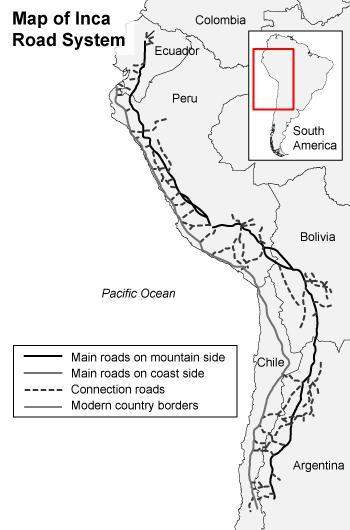

Answers: 3
Another question on Geography
Geography, 22.06.2019 10:00
Northeastern china, north korea, northern japan containing coniferous forests, temperate grasslands, and agriculture, are all part of what climate zone? a. tropical desertb. desertc. humid subtropicald. humid continental
Answers: 1
Geography, 23.06.2019 09:30
Political boundaries are determined by the political party in control at the time. true or false
Answers: 2
Geography, 23.06.2019 16:00
Which phrase describes the time it takes for a planet to make a complete rotation
Answers: 2
Geography, 23.06.2019 17:00
Select the natural regions. delta denver forest georgia north america plateau stream
Answers: 1
You know the right answer?
From the map below, what can you infer about the inca cities? map titled map of inca empire road sy...
Questions

Mathematics, 17.02.2022 01:00
Mathematics, 17.02.2022 01:00
Mathematics, 17.02.2022 01:00


Mathematics, 17.02.2022 01:00
Mathematics, 17.02.2022 01:00

Computers and Technology, 17.02.2022 01:00
History, 17.02.2022 01:00
Mathematics, 17.02.2022 01:00

Chemistry, 17.02.2022 01:00
Mathematics, 17.02.2022 01:00
Mathematics, 17.02.2022 01:00
Mathematics, 17.02.2022 01:00


